Tom Willis, November 12, 2012—Tybo Nevada, a small mining town in Nye County, Nevada, was established in 1875 after a silver discovery in Tybo Canyon. A semi-ghost town today with a few people still living in the town, Tybo produced almost $10-million in silver and lead ore in its heyday, a fraction of what that ore would be worth today!
Tybo got a second shot when the Treadwell-Yukon Company leased the mining property in 1926. By 1930 there were 280 people living in Tybo. Between 1926 and 1937, the mine produced $6.8 million in silver ore. The mill closed in 1937, but until 1945, Tybo ore continued to be hauled to Tonopah for processing.
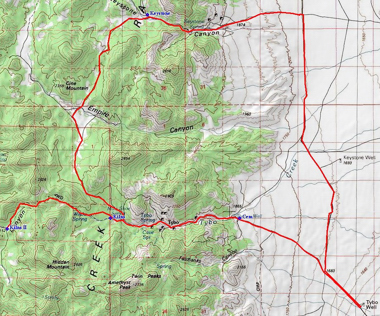
Located approximately 65 miles east of Tonopah, Nevada, Tybo is in the mountains above Hot Creek Valley. Take U.S. Highway 6 east approximately 59 miles to Tybo Road. Drive northwest about 3 miles to Tybo Well, marked by an easily recognizable steel tank. At the turn off Highway 6, the road goes through the base camp for the Central Nevada Test Site. When I was last there, the guard/caretaker was very zealous to ensure our group did not spend any time within his realm.
Tybo Well is located on a large flat that you may have to share with range cattle. It does offer plenty of level space for parking, camping and staging OHVs. This area was the site of an underground atomic detonation in 1968. Some evidence of this can be seen at the northeastern end of the valley.

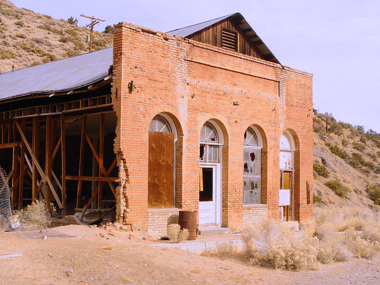
The remnants of the town rest 6 miles northwest of the well. A small cemetery sets on a knoll at the mouth of the canyon. In the canyon, the few remaining brick structures include the general store and school. Keep in mind that some of the houses are still active residences. There is a large steel headframe on the south side of the canyon. The foundations for the mill and smelter are on the north side of the canyon.
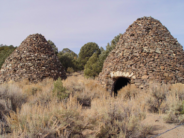
1.4 miles further up the canyon, the road forks. The left fork leads to the Tybo Kilns, accessible at 0.2 miles. These stone charcoal kilns were built in 1874 to supply the smelter at Tybo.
Beyond these kilns, the trail will require either a short-wheel-base 4WD or an ATV/UTV. This trail follows Tybo Creek and Kiln Canyon for 3.6 miles to some brick kilns built in 1876.
Back at the fork in the road within Tybo Canyon, the road to the right leads to Empire Canyon and on to Keystone Canyon. At 7.3 miles, this road reaches the Keystone ruins. Little information can be found regarding the Keystone Canyon Mine, which was apparently operated by Hot Creek Mining Company. You can follow the trail east through Keystone Canyon to Hot Creek Road and return to Tybo Well.

Note: This trip could be combined with the exploration of Lunar Crater, described in an earlier article.—Tom Willis
Tom Willis lives at northern Nevada. Tom has been involved in all aspects of Off Highway Vehicle (OHV) activities for the past 40 years. He has written and published three guidebooks, covering off-pavement travel and activities in the Nevada and California deserts. Over the last eight years alone, Tom Willis has traveled more than 10,000 miles off pavement. Much of that travel has been research for his popular books.
Tom notes that people have been exploring the Far West for almost 250 years, and virtually any place worth visiting has an established trail access! Dedicated to the principles of Tread Lightly, Tom Willis encourages folks to take plenty of pictures and leave only tire tracks on existing trails. When a destination does involve a short walk, Tom suggests that exercise will probably do us all some good!
Tom Willis’ contributions to this corner of the magazine are about places to see, trails to drive and developments that affect OHV recreation in the western United States. His trail-based articles are destination oriented or “loop” trips, and Tom often talks about things you should know to make your explorations more enjoyable!

