Tom Willis lives at northern Nevada. Tom has been involved in all aspects of Off Highway Vehicle (OHV) activities for the past 40 years. He has written and published three guidebooks, covering off-pavement travel and activities in the Nevada and California deserts. Over the last eight years alone, Tom Willis has traveled more than 10,000 miles off pavement. Much of that travel has been research for his popular books.
Tom notes that people have been exploring the Far West for almost 250 years, and virtually any place worth visiting has an established trail access! Dedicated to the principles of Tread Lightly, Tom Willis encourages folks to take plenty of pictures and leave only tire tracks on existing trails. When a destination does involve a short walk, Tom suggests that exercise will probably do us all some good!
Tom Willis’ contributions to this corner of the magazine are about places to see, trails to drive and developments that affect OHV recreation in the western United States. His trail-based articles are destination oriented or “loop” trips, and Tom often talks about things you should know to make your explorations more enjoyable!

Lunar Crater, Nevada—U.S. Highway 6
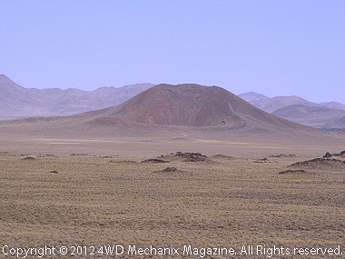
Tom Willis, August 10-24, 2012—Our first trail ride takes us to a very unique area in south-central Nevada. The area is Lunar Crater National Natural Landmark.
This volcanic area was active about 2000 years ago. The area straddles US Highway 6, about 75 miles east of Tonopah, Nevada. There are not any traveler services along this stretch of highway, so get your fuel, food, and other supplies before you leave Tonopah, Nevada—cellular phone service is poor at best.
I have heard claims that NASA used this area to provide some training for the moon landings in the 1960s. The area is open to Off Highway Vehicle travel, but cross country travel is restricted. There are not any visitor services (water, restrooms, campsites, or a visitor center) at the site. But the area offers some of the best primitive touring and camping found!
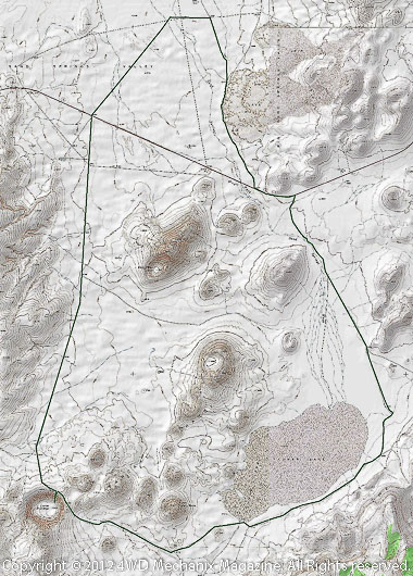
Due to the heat, the best time to visit the area is in the spring or fall. As you approach the site on the highway, there are Bureau of Land Management (BLM) signs marking the turn offs. The trail is known as the Lunar Crater Backcountry Byway and is shown on the map included here.
The byway is 24 miles long and takes you through an incredible volcanic landscape. There are minor trails throughout the area that provide access to almost every formation. The main route requires a high clearance vehicle; some of the minor trails may require four wheel drive.
Lunar Crater itself is a single large crater that from a distance looks more like a meteor crater than a volcano. This main crater is 430 feet deep and about 4000 feet wide. It is surrounded by 20 or so smaller cinder cones and craters.
Easy Chair Crater is another large crater, north of Lunar Crater. There is a lake east of the Lunar Crater which is often dry in the summer. The Black Rock Lava Flow is on the north side of US Highway 6.

For maps of this area, I recommend the Bureau of Land Management (BLM) Surface Management series. Use the Warm Springs and Quinn Canyon Range quadrangles.These can be obtained through any BLM office in Nevada, priced around $4.00 each.


